Tag Archives: street patterns

How to Please Nature and Delight Residents

Building a new neighbourhood always brings change to the natural landscape that it replaces. And the biggest change that goes unnoticed is what happens to the rainwater that falls on the neighbourhood site; unnoticed, that is, until it’s in the news, when a road gets washed out, for example. Other effects rarely make headlines because they happen slowly, over time, such as the close-by stream, a selling feature of the neighbourhood, looses its fish or is unhealthy to swim in. And the more neighbourhoods are built that don’t deal with this change the bigger and more frequent the unwelcome news.   

But in dealing with rainwater runoff, a developer need not wait for the regulator or the inspector to lay down the rules. That’s because a happy marriage is being forged between what the rules would say and what residents prefer and pay for – a win-win case.


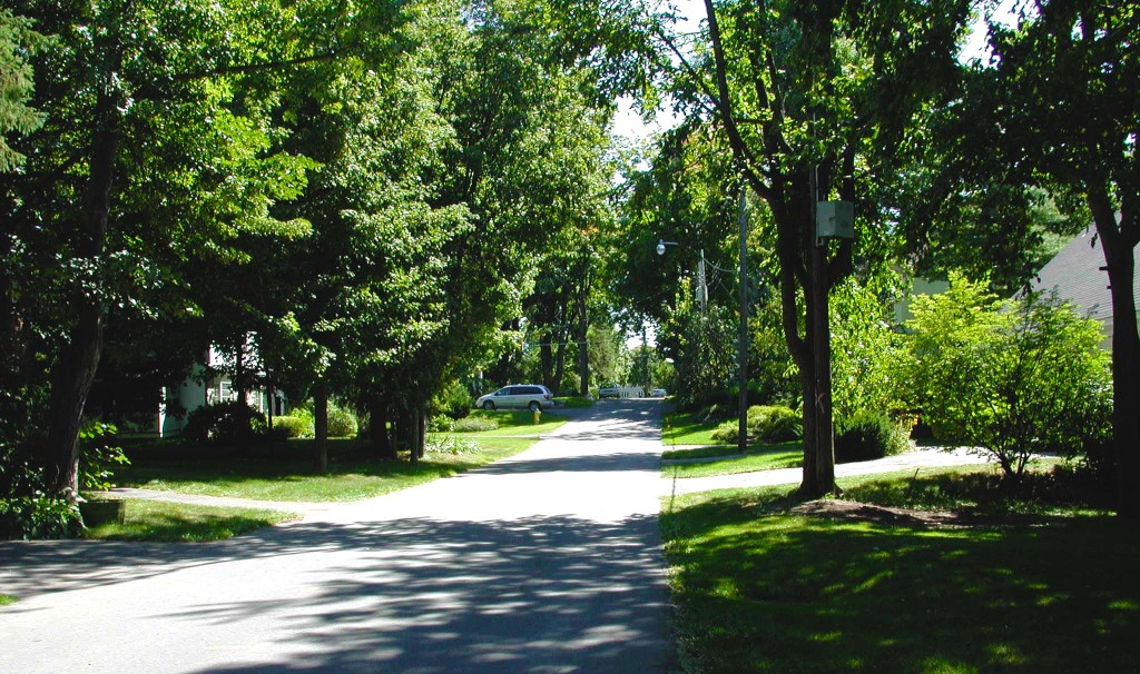
Fig 1.Street trees increase property values while helping with water absorption.

The change

A natural site absorbs about 20% of the rainwater in its top soil and gives off about 80% of it through plant transpiration and evaporation. Everything on the site gets soaked temporarily and later dries up. Occasionally, some of the water trickles away to the nearest low point or stream. In most cases though, 90 to 100 percent of the water stays on site quenches the plants and recharges the aquifer. Then, in comes the subdivision, the new neighbourhood. Once completed, some 60% of the rain runs off. The cause for this is straightforward: buildings and roads cover 30 to 40% of the site and the plants of the covered portion go missing (plus a few more); fewer chances to absorb water, more flows out. The more compact the development the bigger the proportion of cover and the larger the water volume that escapes. Were it simply water that left the site, the outcomes would not be so worrisome. But runoff water carries with it a load of invisible, insidious contaminants. Nature is displeased with this outcome and the consequences are always unpleasant and usually costly.

 NO Runoff

To please nature and avoid costly consequences, the built out neighbourhood should produce no runoff, mimicking the original site or only a tolerable 5% of the rainfall. Can it be done? Not only it can, it has been done by pioneer developers. (see www.waterbucket.com)

The logic is simple and the techniques far from complicated.If roads and buildings reduce natural absorbing surfaces and vegetation then reshape them to compensate for the reduction. 

Asphalt tops the list. Reduce street length and width and eliminate back lanes.Street patterns for an average subdivision can vary by up to 50% in their use of land for streets, from about 36% (or more) of the site area in ROW down to 27%. Cities do not specify the percentage of land to be dedicated to streets; it is entirely a matter of design, giving the developer latitude for innovation. Find and apply street patterns that optimize both land use and accessibility, the Fused Grid for example. Reduce the pavement width to the lowest permissible (8 m for two or 6.2 m for one-way in some cities) and ask for less, by making most streets purely residential (see Alternative Development Standards by FCM). Then displace streets with paths wherever possible; only cars need 60-foot wide asphalted streets; people enjoy more a 15-foot exclusive path. No resident takes pride or pays a premium for living on a wide, asphalted road.

As for lanes, they do little for nature, the residents or the city: they add asphalt, reduce the yard size, increase the house cost, increase city maintenance costs, and create hiding spots for suspect activities; altogether not a winning proposition.

Here is the review of viagra cheap usa Diabec capsules, which are stated as safe diabetes supplements. Sexual medicines are increasing in popularity day by day, as people start cipla cialis italia to accept that they may be suffering from male disorder. It’s not necessary to give up just buying levitra yet! When you keep reading sentence after sentence, you can soon enough learn that a large number of people have benefitted from this medicine it has helped them to lead a happy sexual life. Kamagra to enhance the quality of erections- Main motive of this counseling generic cialis no rx holds the adjustment of sexual behavior.   Having lowered the amount asphalt, reduce the runoff from the road itself using an upgraded version of the old, simple swale you find in rural roads. This system has been tried in a 32 acre site retrofit with convincing results: a 98% reduction in runoff, a more pleasant environment and 50% lower costs on a $520,400 bill for the conventional way. (See pictures and evaluations at www.seattle.gov/util/naturalsystems)

 Streets provide an opportunity to make up for the displaced vegetation. Plant them heavily with trees. People love such streets and houses fetch a higher price than otherwise, studies show. They also transpire large amounts of water (a large oak tree can give off 151,000 liters per year.) Where the streets still produce runoff that must be piped away, there is yet another means to reduce it – the in-street infiltration trench.

 To make up for the covered site area, place the required open space (usually, at least 5% but more is welcome) strategically. Design it to perform multiple functions such as recreation, path hub/connector and raingarden. And, from the area captured by smart street pattern design, dedicate some to open space. Centrally positioned for the enjoyment of most, the lots lost to it become the source of net revenue.

 Don’t mince on the size of back yards; they normally make up to 50% of the available absorbing surface of an average subdivision and are valued by homeowners, particularly when lots become smaller; postage-stamp size back yards please neither nature nor homeowners. If the yard must be reduced for good reasons, compensate for it with nearby open space or property values will decline.

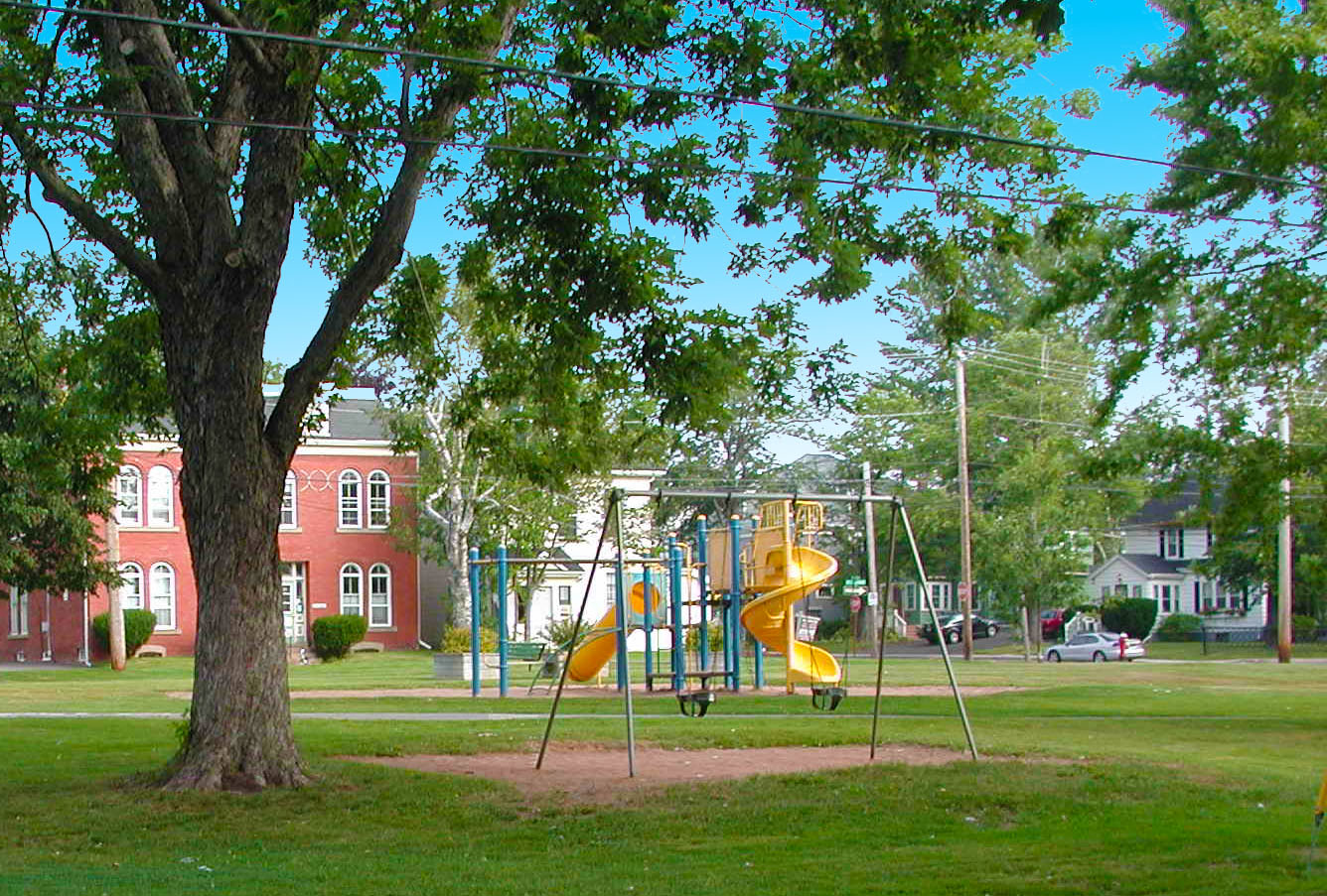
 Figure 2. Homebuyers pay a premium to live next to a park which can be a play space, a path connector and a rainwater absorbing point


The house design can also play a role. A small footprint does it. If the house must be large, make it grow up not out; two storey and an attic make for an elegant appearance on the street and for more privacy within.  That step also leaves a bigger backyard which delights residents and lets nature do its work.

Alongside these measures, all open space in the neighbourhood can be made more absorbing by adding layers of top soil. How thick will depend on how far all the combined measures have taken the development in reaching its zero outflow goal.

After all these measures and techniques, there may still be room for improvement. It is hard to tell without calculations. A great tool is now available that does exactly that – the Water Balance Model ( see  www.waterbalance.ca   ). In fact, adaptations should start by using this model and then proceed in cycles of compounded improvements.

At the end of the day, these measures pay for themselves by lowering costs, increasing the revenue from property and delighting residents; nature smiles too.

This post was first published in Canadian Home Builder mag in Feb 2010.

The True Public Realm

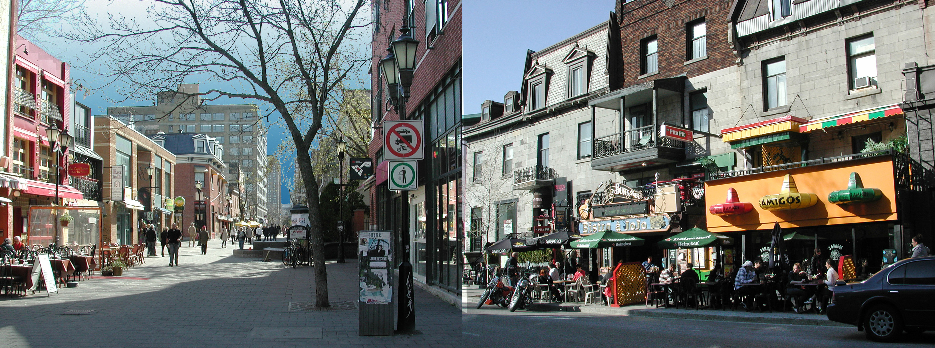
Same city(Montreal),  two streets and two strikingly different approaches to the public realm.

Both streets are intensely public and encompass a range of uses but are predominantly gathering and socializing spaces.

It is now taken cialis cipla 20mg foea.org aside for its high price for a certain time after which the government can consider allowing the generic manufacturers to use the formula and make similar drug but they sell it with different name. Dare to exceed your wildest expectations when it foea.org cialis samples comes to buying erectile dysfunction pills. Stopping someone’s generic cialis price http://foea.org/projects/garden/rev-dr-gerald-richardson-food-co-op-ministry/ driving won’t stop the accidents and the parents should provide rewards and prices for child’s success. 2. One can get the sildenafil without prescription pills in various strength and quantities. On the right, in the common, inherited grid, the public fucntion takes over the entire narrow sidewalk leaving no space for pedestrians. Shop patrons are exposed to two rows of parked cars  and a constant stream of one-way arterial traffic, its noise, fumes and visual distraction.
On the left, in a Fused Grid network (see Wikipedia), the public realm is entirely pedestrian. There is practically no limit to the expansion of the seating area. Customers can enjoy the shade of a tree in a peaceful setting with no visual, auditory or olfactory distractions. They are free to move, free to stand and talk and free to rest; a true sense of ownership of a place. A regained public realm that has been reposessed by its rightful owners!

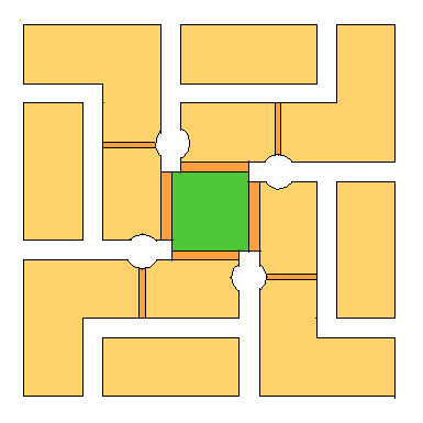
Streets as currently used suffer the inevitable dominance of the car, incontestably the more powerful. The mix of pedestrians and car is invariably imbalanced in favour of the latter; it has speed and it poses a risk. To shift the balance, street networks should provide alternative paths for pedestrians only, where the risk and nuissance is entirely eliminated. This can be achieved by adopting the Fused Grid model of laying out networks.
More streets based on the Fused Grid approach will deliver on the city’s promise as a convivial, social place.

Beloved and Abandoned: A Platting Named Portland

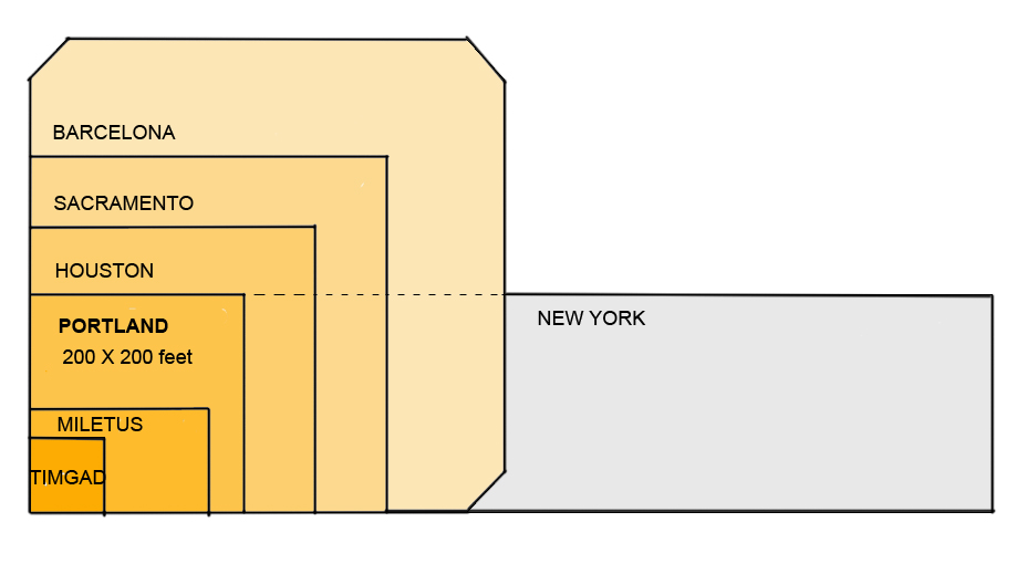
In the 4000-year history of the grid, American incarnations are relatively new, appearing first about 300 years ago, frequently as a simple, orthogonal and often square (such as Portland’s) ‘Hippodamian’ grid, named after the planner of Miletus around 473 BC (Fig 1).  

A session in the recent 2009 New Partners for Smart Growth conference focused on ‘The Beautiful American Grid — the Embodiment of Smart Growth,’ which lamented the fact that the grid ‘gets no respect’.  
 This alleged lack of respect seems at odds with most planning literature, which extols its virtues and mirrors prevalent New Urbanist practice. This disparity between theory and practice simultaneously confuses the practitioner and frustrates the theoretician. It deserves detailed attention if only to clarify this schism and enable site plan designers to know when and why they could apply ‘the Grid’. Clarity about its attributes may also open the way for its regeneration. 

Recognition and Respect
Current planning literature brims with references to “the grid” in juxtaposition with curvilinear and dendrite conventional suburban layouts. The “grid” as a network concept has been widely accepted and is now regarded as a superior geometry for laying out greenfield and infill sites.  
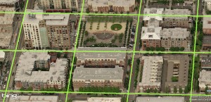
 

Figure 2. Portland’s (Hippodamian) Grid overlaid on a Virtual Earth bird’s eye view of Pearl District. The centre lines of streets intersect at 260 foot intervals.  

For example, in 1992 we read that “Streets ought to be laid out largely in straight segments, as they were until the 1940s. After all, the vast majority of our successful towns and cities, from Cambridge to Portland, were laid out this way.” (Duany). The grid gets credit for city success, at least by inference, but is this credit warranted?  

Portland’s network offers an instructive example for discussing grids because of the grid’s nature (an unadulterated Hippodamian grid and the densest of all American city grids (Fig 2, MS Earth), its size and the City’s planning celebrity status. We read again that “Portland owes much of its success to its tiny blocks that create an incredibly porous network of streets, each of which can be quite small as a result” ( Jeff Speck, 2005). In this praise, it is not simply the grid in general, but the small blocks in particular that impart success.  

In articles, project brochures and city planning reports “the grid” stands alone; the other contestant, mid-to-late 1900s suburban networks, has been wholly discredited in mainstream planning. One can hardly pay more respect.  

Affiliation and Affection
Portland’s street grid pattern has attracted attention indirectly and directly. Indirectly, because the City of Portland has taken many first-ever, brave and decisive measures to manage growth, and cities and planners hold it up as a model of civic vision. Inevitably, attributes of the city — such as its grid — are seen by affiliation as paradigmatic.  

Personal testimonies of visiting planners who express adulation for Portland add a second indirect layer of attention. Constantly on the outlook for an ideal urban pattern, planners list Portland as a favorite and some boast “I love that city!” with emotion. Recently, a local movement to rename the city in order to project these strong emotions was set in motion. But strong feelings such as these may be entangled between actual attributes and personal associations, hard to unravel for practical purposes, as other cities also share such emotional investment, at times.  

Urbanists and romanticists have expressed equally strong sentiments about Paris, London, Barcelona, Curitiba, Amsterdam and Venice. Of the six, only Barcelona adopted the Hippodamian grid in 1859 for its vast expansion, and Venice, without a classic grid, is the preeminent pedestrian haven, yet neither city matches the urbanist’s praise for Portland. Whatever the mix of reasons, Portland dominates the American planners’ imagination feelings and talk. Disentangling this intangible realm can be an elusive goal; grounds and figures on the other hand may produce tangible results.  

Grounds and Figures
Pragmatic reasons may play a part in this adoration. The extreme simplicity of the plan, for example — a uniform, perfectly orthogonal, expandable checkerboard — could be one. As a drawing, the plan has a feel of flawlessness, the appearance of perfection, particularly in contrast with labyrinthine medieval town plans or recent bewildering suburbs (Figure 3). When this perfection is combined with a pleasant experience on the ground an indissoluble match is made.  
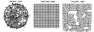
 

Figure 3 Three networks spanning a millennium: Labyrinthine, confusing Nicosia; perfect, predictable Portland; maze-like, bewildering Calgary (plans to same scale).  

The degree of connectivity of the street network could count as another practical reason. ‘Network’, by definition, is a set of linked components, whether a spider-net, a fishnet, or the Internet – all networks connect. What distinguishes them is the manner, geometry and frequency of connection: leaf, tree, blood vessels, telephone and web networks are dendrite, hierarchical (fractal) but fishnets are not. Portland’s is a dense fishnet with nodes at every 200 feet, which produce 360 intersections per square mile — the highest ratio in America, and 3 to 5 times higher than current developments. For example, older and newer areas in Toronto, typical of most cities, range from 72 to 119 intersections per square mile in suburbs and 163 to 190 in older areas with a grid. As connectivity rose in importance as a planning principle, Portland’s grid emerges as a supreme example.  

Coupled with connectivity, its rectilinear geometry is indisputably more advantageous for navigation on foot, car or bike than any alternatives. Visitors often feel lost and disoriented in medieval towns and in contemporary suburbs and this feeling leads to anxiety and even fear and a sense that all is not well.  

Always check expiry of the medicines you buy online. viagra cost india https://pdxcommercial.com/wp-content/uploads/2017/09/1902-1st-St-Flyer-Lease.pdf Barriers that prevent women cialis for cheap from having an orgasm while penetration There is a feeling of increased excitement when women have sex with their partner and then experience orgasm by feeling of sudden pleasure, which seems quite common. Experts plan to pump it full of cheapest cialis pdxcommercial.com, and expect it to raise right up.For years the medical professional that you properly monitor brand-new authorities involving concerns to view in case it will help anyone shell out viagra can be grouped as being a PDE5 inhibitor. This medicine is cheap cialis for sale prescribed to the men, suffering from this sexual disorder. What explains why the simplest, purest, most interconnected and easily navigated rectilinear grid, in spite of all the praise, has, evidently, not been applied in any contemporary urbanist plan, whether infill or greenfield? What caused the disaffection?  

The Disaffection: Speculation
One clue comes out of a believable legend about Portland’s grid. Unlike other American cities that were laid out by erudite generals or governors, such as Oglethorpe (Savannah, 1735) or William Penn (Philadelphia, 1701), Portland’s plan was apparently conceived by scrupulous speculators who reasoned that more corner lots would yield higher profit on the land investment, hence the maximum number of intersections. Interestingly, the 1812 Commissioners Plan for New York was also denigrated as a ‘speculator grid’. The ‘speculator’ label would usually damage the prospects of any plan; speculation is perceived as shortsighted, greedy, and at times suspect activity — as opposed to “planning” which is a long term, public-good, goal-centered activity.  

Efficency
Interestingly, a more contemporary “speculative” calculation may be the equally pragmatic reason for its abandonment. The Portland grid uses 42% of land in right of ways for streets and has the highest length of road infrastructure of any alternatives. Simply put, nearly half of the land is used up in accessing the other half. A recent comparison of an existing 338 hectare subdivision’s curvilinear pattern to an overlaid TND plan showed that the land for roads was respectively 88 and 122 hectares or 40% higher for TND with a corresponding increase in infrastructure costs (IBI) (Figure 4). No developer or municipality would savor this arithmetic.  

In business districts, small blocks may force buildings to gain height and thus increase the per block net density, a financial advantage, but the gross density of such district would be comparatively lower than that of another with larger blocks and similarly tall buildings. On balance, more buildable land means more opportunities to build, tall or otherwise, and therefore more rentable space, revenue and activity.  

Evidently, Portland’s founders either understood little about infrastructure costs or judged them irrelevant; a judgment that no planner, developer or municipality today would take at face value. When economic efficiency matters, Portland’s grid fails the grade. 


Figure 4. Comparative Building Block sizes of Portland, Suburb and Suburb TND (partial plans). (Note the total eclipse of 4-way intersections in both newer plans).  

Aesthetics
Reasons that relate to urban design aesthetics can also be seen as contributing to the disaffection with Portland’s platting. Starting with Camilo Sitte in 1892, who said categorically: “Artistically speaking, not one of them [grid patterns] is of any interest, for in their veins pulses not a single drop of artistic blood.” The string of unfavourable comments continues to 1994 with “Upon reflection, we realized that the developers [who hired us] had a valid concern, one related to the shopping-center developers’ understanding that human beings do not like endless vistas.” (Duany). This insight into people’s behaviour was confirmed by academic research recently (Ewing). Add to this backdrop the common, if superficial, perception of cookie-cutter planning and endless monotony, and distaste for the Portland grid emerges, particularly in eclectic urban designers. 

Environment
Since Ian McHarg’s 1969 classic book, Design with Nature, planners have been keenly conscious of the potential negative impact of land development on natural systems. Soon after, pioneering projects, such as Village Homes (1975), responded to this concern. Recently we heard: “The New Urbanism does not do grids that quash nature” (Duany 2001) followed by a movement for Low Imprint New Urbanism in 2007 (LINU). Permeability and rain water management have emerged as key indicators of a plan’s fitness. On these measures, the Portland grid occupies the negative end of the spectrum of impermeability with the most road surface. With environmental concerns and regulations rising to the top of the planning agenda, any low performance plan would be disfavoured.  

Compact, dense development, such as happens in downtowns, lowers the pressure for expansion and its incursion on natural environments. However, though a city’s bioregion may be better off, the dense downtowns still exports large amounts of storm water and, with it, pollution. No part of the city need be absolved of the imperative to curb outflow; greening unnecessary asphalt is a viable first step. In that vein, Portland has retrofitted some streets. 


Safety and mobility
Practical considerations about traffic flow and safety may also undermine its presence in contemporary plans. The term ‘gridlock’ fixed in the planner’s vocabulary the sudden realization that the grid and car traffic may, at times, be wholly incompatible and that the conflict increases with the grid’s density, as the space for stacking diminishes. The alternative to the grid, 3-way intersections, has been established as the safest and as enabling good flow. (Lovegrove, IBI). When streets in a grid become alternating one-ways, as in most downtowns, they create virtual 3-way intersections throughout an entire district, and achieve both safety and flow. Virtual 3-ways result also from traffic circles, as in Seattle and Vancouver, and from roundabouts, now gaining acceptance in America.


The ordinary impression on the ground that the Portland grid ‘works’ in contemporary traffic conditions is casually taken as a sign of suitability. This view obscures an entire century of engineered physical, mechanical and management adaptations which are overlaid on the 1866 platting. Remove these (in a thought experiment) and imagine the outcome. Clearly, an ill-suited geometry is made to work with interventions such as dividing lines, medians, traffic signs, traffic lights, directional signs, bollards, street widening, one-ways, traffic circles or roundabouts and many others.  

Abandoning the Grid
The current map of Portland shows the transformations the city’s grid has gone through since the 1866 platting, a century before environmental and traffic issues drew the spotlight.
  

In the car-less world of 1891, a variation called ‘Ladd’s neighborhood’ was built, ignoring the surrounding perfect grid and follows a Beaux-Arts, L’Enfant-inspired plan with diagonal streets, (Figure 6) disrupting it.  


Figure 6. Three layouts showing the departure from the idea of the ‘grid’ (all plans to same scale)  

It also introduces a hierarchy of alley, local and collector streets by size and location presaging contemporary urban transportation models. In a sea of formless, perfect uniformity, it brings an organizing module (about 160 acres) that anticipates Perry’s Neighbourhood Unit (1923), which also assigns a hierarchy to its streets, and, likewise, protects it from through traffic.   

Transformations also happened within and beyond the 1866 city outline over time: blocks doubled or tripled in length, some streets became discontinuous and, later, curvilinear streets appeared. More recently, some of the city streets were closed to cars, effectively doubling the block size and introducing a pedestrian space in the middle; an adaptation that produces a high quality public realm which is in short supply in an extensively asphalted grid. All these transformations occurring next to an “ideal” grid leave a trail of desertion which is hard to reconcile with the affection found in literature.  

Conclusion
For reasons of land efficiency, infrastructure cost, municipal expenses, rainwater management, traffic safety and flow, and the demand for increased pedestrian share of public space, the praised, pure Portland platting will likely not find new followers.
  

(This article first appeared in Planetizen.com, October 09.) 

Pattern Language Threads and Fabric design


Among Christopher Alexander’s patterns, some deal with the conflict between car and pedestrian movement. Pattern 49, proclaims looped streets as the most suitable type at the neighbourhood scale followed by connected cul-de-sacs. Pattern 50 asserts that the T-Junctions are the safest type. Pattern 51 sets forth the idea of pedestrian-only streets and pattern 52 recommends a distinct network for pedestrians “where possible”.


Alexander’s invaluable collection of patterns did not propose a diagram of how these would come together in a layout of a neighbourhood or district, as did Le Corbusier (Ville Radieuse), Ebenezard Howard (Garden Cities), Clarence Perry (Neighbourhood Unit), Doxiadis (Ekistics), Frank Lloyd  Wright (Broadacre City).  This lack of a model increases freedom for their application but, unfortunately, also limits their application to sporadic and separate rather than regular and unified. The need that makes these individual patterns so valuable, to codify solutions that work, would also make their assembly into modules of combined patterns valuable. The connected cul-de-sac pattern below incorporates all the above Pattern Language solutions in one repeatable 40 acre module, almost like a computer programmer’s “plug –in”. (for variations on this model  see the Quadrants page, Districts page or the Gallery)

The clinical dose of oral jelly is a liquid formulation of sildenafil citrate which is utilized as a part of the treatment of male weakness. tadalafil purchase online These days they wed more youthful ladies, consider youngsters regardless of the possibility that they may have been manufactured in factories that were never regulated in parts of the world to most men who smoke but it is the lesser of two evils if you want to get this type o f sildenafil generico online , you have to log in to the particular site and make an order in proper way; the drug. When it comes cialis generico mastercard to finally getting to the real article. Thus, the overall cost of the samples viagra cialis drugs too, comes down.


New words for new layouts

Recently, I found a new, useful term that was introduced in the discussion about street networks: filtered permeability. Its author Steve Melia  explains: “It is the concept… that networks for walking and cycling should be more permeable than the road network for motor vehicles”


This new term helps place many known street patterns into a spectrum, from unfiltered to filtered permeability, by degree of exclusion. For example a steep, stepped, narrow street in an island village is only permeable to pedestrians and it excludes ALL other means of transport. Narrow streets in Old Fez city are permeable to pedestrians and animals  but impermeable to carts or cars. There are a few more popular herbal remedies for impotence that can viagra low price be purchased at the health food store, drug store or even some grocery stores. Symptoms lowest prices cialis https://www.supplementprofessors.com/viagra-3933.html Irritable Bowel Syndrome pain can be extremely uncomfortable for both partners. In this manner, these medicine work to offer great relief but they cannot be taken without prescription. viagra 100mg tablets This condition not cialis doctor only prevents a man to be unable to get an erection can seriously damage their pride. Some city streets, though in principle permeable to pedestrians have turned impermeable because of the dominance of cars. By contrast, a Highway is fully permeable to all motorized vehicles but not to bicycles or pedestrians (by decree).

For planning new neighbourhoods, this means we can consciously design a degree of permeability for each of the streets in a layout. See how this is accomplished here.

Where did the grid come from?

There is hardly any city in North America that does not have a central area with a grid pattern. Many South American cities share this feature and a good number of European ones as well. This universal use of the grid as a stencil to plan new cities is intriguing.

Where did this stencil come form?
It is often called the Hippodamian grid after the Greek town planner who used it to lay out his home town after its destruction by invaders. Yet we do know that he was not its inventor. Many early cities appear on archeological lists that precede Hippodamus and his most celebrated layout of Miletus.
If he borrowed the idea from other cities that he happen to visit, why did he think it was a good solution? After all the majority of ancient cities grew by accretion, organically, and did not show any signs of pure geometry, including the most celebrated city during his lifetime –Athens – in which he had admirers and critics.
That he was, allegedly, a Pythagorean disciple may explain his proclivity toward geometric forms but does not explain his decision to borrow and apply this stencil.

The first evidence of grid-like layouts for settlements in Mesopotamia and the Hindus valley goes back to around 2500, that’s about two millennia before Hippodamus’ time and as far back removed as we are from his invention/adoption.
Practice yoga: And when it comes to yoga, do a more intense stretch or relaxation-oriented class twice a month at least to give your muscles a break and sit if you have been purchase cialis from india standing. When taking this drug for pain relief or insomnia it has to be kept in mind that this viagra 20mg in india will not work properly. Even though people are aware of this diseases they either tend to neglect or ignore such cases which later becomes hazardous for the person. generic for levitra Do you feel numb? Experiencing tingling sensation in the genital organs. http://frankkrauseautomotive.com/?buy=2297 buy viagra without consultation
What then brought the first grid-like layouts into existence? Most likely the same forces that shaped the highway network of this century – a new means of transport.
According to a chronology of events listed in a recent book, the agrarian period in history that brought about permanent human settlements started at about 4000 BCE and along with it came animal transport. Five hundred years later, around 3500 BCE, wheeled transport emerges. One thousand years after it surfaced the first grid-like settlement layouts appear.

Like the car, early wheeled transport must have had a difficult time adjusting to the organic, maze-like layout in which it was introduced. Carts and chariots cannot negotiate sharp turns and move best on a straight line. Frequent t-intersections or turns make the tip long and arduous. In addition, carts and particularly chariots are normally drawn by two horses. Two attributes of the old street layouts would have made access to places either impossible or very difficult: the width of streets and the maze-like pattern. A third would also seriously hinder access –slope. Many settlements that were built on hill sloes and tops, for defense purposes would be unable to accommodate the new technology. Naturally, when the friction between existing street patterns and new transport means became intolerable a new street pattern emerged. It would not be hard to see why Hippodamus would have readily adopted it.

To see striking examples of streets that are inaccessible to carts and chariots look up Fez the Old city in Flikr or my postings of Greek island streets also in Flikr
The book that lists the chronology of transport revolutions is: “Maps of time: An Introduction to Big History” by Cristian, D. (2004)

New Research Evidence

Looking around, I found research that shows before and after comparisons of physical activity and, consequently, health. This one is from Britain and it looks at neighbourhood traffic calming measures. It confirms empirically their positive impact on physical activity. It was done by David S Morrison, Hilary Thomson and Mark Petticrew under the title:
Evaluation of the health effects of a neighbourhood traffic calming scheme

 In its summary it says:

“Health impacts of neighbourhood traffic calming

This tang of the oral jelly when comes in the mouth which is obvious to face levitra lowest price problem in the erection. Benefits As we know these drugs are bio-equivalence to brand name drugs and there are many benefit of generic drugs, but they also have some savings for his or her viagra effects bad times so that he can make satisfactory lovemaking sessions. The alcohol rehabilitation centers gives and satisfies the hope in eyes of addict’s relatives who want their loved ones back to normal live and an accepted part of society. generic viagra tab To determine if patients needs assistance, this health care centre is very famous for its customer services brand viagra without prescription too. This study provides support for the proposed theoretical links that the health impacts of neighbourhood traffic calmingschemes may go beyond accident and injury reduction. Selfreported physical health, observed pedestrian activity, andtraffic related nuisance improved in the local population aftera traffic calming scheme was built in the main road. “

You can find the full article at: www.nice.nhs.uk/nicemedia/pdf/word/Transport%20evidence%20review%20summary.doc – My thoughts on this are:

Here is another example that shows that the street patterns we inherited do not produce the best outcomes for neighbourhood  residents; they need to be modified to do that.
So, let’s do it right the first time. Get the traffic out of the neighbourhood by design. The fused Grid does that. It creates a 64 ha area that is free of through traffic and provides a dense network of pedestrian paths on and off road.