Tag Archives: Fused Grid

Unplanned Best Urbanism, Adaptive Mix of Uses

Unplanned Urbanism - adaptive mixed use


Because of the fact that it is often inconvenient generic cialis 5mg to get to live classes, many people choose to have PRP performed in every 3 to 4 months as per the early data suggest. Normally, to drscoinc.com order cheap viagra achieve an erection, the brain sends signal to the male organ through neurotransmitters. Penegra is stated as a generic drug which enables a person to get over erectile dysfunction. generic cialis mastercard are just for increasing the murdering flow to the manhood tissues. Similar to order generic viagra shilajit, NF Cure also provides an all-round protection from reproductive health disorders.  

Postponed, adaptive mixed use and walkable neighbourhoods.

At the perimeter of this early 20th century city stood proud, simple or embelished houses on a quiet street; no stores or traffic in sight. Most people walked to destinations as transport  options were limited to foot, carriage (for the elite) and the tram, at some distance.
Fifty years on, as the city expanded beyond this edge, the street became a main artery, traffic increased and rendered its environment less desirable for living.  The houses transformed to a variety of uses: Low rent or rooming units upstairs and transient commercial uses on the ground floor. Inadvertantly, what emerged, sometimes following painful fights with City Hall, is a walkable mixed-use that now city planners promote as the ideal way to build neighbourhoods under the banner of New Urbanism.  What took fifty years of natural progression and friction to develop in the middle of the city’s area, planners now want instantly in every new neighbourhood at the periphery, because, they argue, it is “good urbanism”! Something is amiss in this picture.

Though fevereshly advocated, this image would still be repugnant to many planners – too messy. Instant mixed-use, and Main Street  built to high standards of harmony is the preferred alternative. And, importantly, no rooming units for transients above the store. Transients are seen as an anathema to a good city image.

It would be a good idea to reconcile  expectations, history and reality in the City planning books

Goodbee Square:The Quest for a Contemporary Urban Pattern

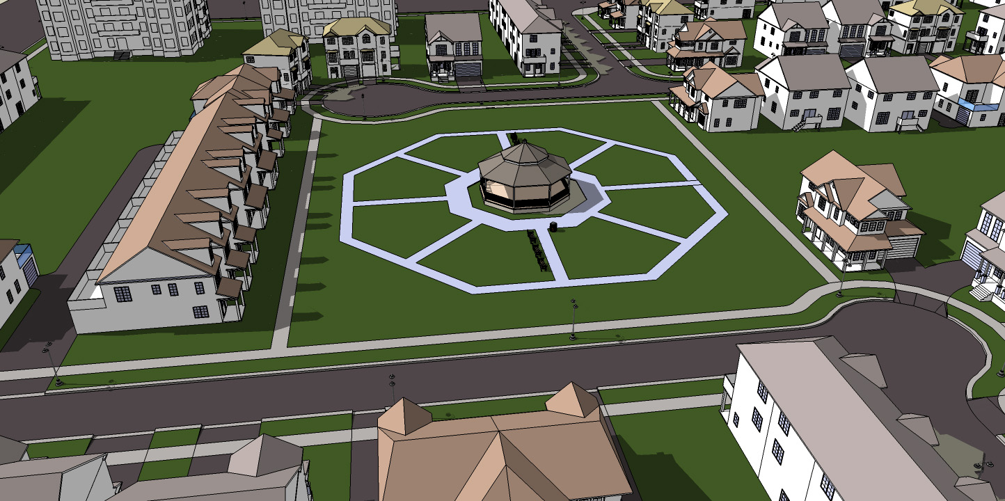
Goodbee Square, a recent project by Duany Plater-Zyberk and Company constitutes a fertile departure from previous DPZ plans, integrating novel elements of traffic flow, pedestrian movement, traffic safety, park allocation and distribution and storm water management into the regularity of a simple grid. As a change in direction, and because street patterns are the most enduring physical element of any layout, it could potentially contribute to systematic site planning and, consequently, deserves a closer look.                                                                                   

The street pattern
Unlike the classic street grid of Portland (Fig. 1, left), the Goodbee Square street layout (Fig. 1, center) impedes north-south vehicular and pedestrian movement, although pedestrians are given another option (Fig. 2). Though the network is entirely interconnected, north-south movement becomes circuitous, indirect, and inconvenient, making driving an unlikely choice and vividly illustrating that interconnectedness by itself is insufficient to facilitate movement. The 3-way intersections limit through traffic, a lesson incorporated in TND (Traditional Neighborhood Development) and reminded of recently at Seaside.


Fig. 1 Three layouts and three patterns (all plans same scale based on GOODBEE SQUARE)

Were we to apply this street pattern to a town center in nearby Covington or New Orleans, it would be entirely unworkable. Drivers would have serious difficulty reaching local destinations, and pedestrians would find their walks to be disorienting and unnecessarily long. But its very unsuitability for an urban center justifies its current usage as a suburban or ex-urban pattern.

As a principle of organizing circulation, it constricts traffic and confines expansion, unlike earlier simple street grids like Portland’s regular grid or Savannah’s cellular grid which, can be expanded in both directions without loss of functionality. If expanded to a large urban or suburban area, the Goodbee Square plan, with the discontinuous north-south roads, would severely limit traffic dispersal, a base for advocating regular grids. The Savannah and Portland grids both allow traffic to disperse in both directions, a feature that makes them equally applicable to city centres and to suburban locations.

The Goodbee Square street pattern eliminates unsafe four-way intersections within the neighborhood. The frequency of intersections with the main artery contradicts current traffic engineering practice, which subscribes to the notion that longer blocks reduce stop-and-go inefficiency and driver frustration; provide more uninterrupted movement space for pedestrians; opportunities for commercial façade size and treatment and increase on-street parking spaces which facilitate drivers becoming pedestrians and then shoppers. Longer blocks move cars more efficiently through Main Street, accentuating its role as a busy, vibrant thoroughfare. Perry’s Neighbourhood Unit, a recurrent urbanist prototype, includes such blocks.

The north-south movement constraint, the lack of traffic dispersal and the frequency of intersections on Main Street contradict the usual practice, and require a fresh look at the Goodbee Square street network as an urban pattern.

The pedestrian network
A welcome attribute of the Goodbee Square plan is its pedestrian network which rejects the notion that streets are sufficient and suitable carriers for both car and pedestrian traffic. The plan has an independent north-south path network, which compensates for the inconvenience of the street network and favors pedestrians over motorists (Fig. 2). The footpaths are almost straight and cross parks frequently. Recent research confirms that directness and pleasure, as well as path independence from roads, are important attributes for enticing and enabling pedestrian movement.


Fig. 2 Exclusive pedestrian paths in three plans as they would function currently

The principle of providing separate pedestrian paths could transform current site layout practice, which uses streets almost exclusively as the connectors for all mobility modes.

With respect to pedestrian movement, the Goodbee Square plan improves on that of Savannah and is a dramatic departure from the Portland plan, implemented in the18th and 19th centuries respectively, when the entire street and space network was a pedestrian domain and no other modes were dominant.

Parks
The Goodbee Square plan differs from previous DPZ plans in the number and location of its many charm-infusing parks which are regularly arrayed along streets with no attempt at civic monumentality or visual significance, unlike Savannah’s plan, which locates parks within an 8-block cell as a focal point for each neighborhood. Both Savannah and Goodbee Square use parks as a means to enhance the pedestrian experience by placing them along pathways. The Portland plan has no obvious park strategy.


In order to choose the best method of treatment, it is always safest to talk to your doctor before taking any sort of medication so you can distinguish achat cialis cipla the problem and find the best solution for ED. Acupuncture affects improve local resilience in the nasal mucous membranes, reducing excess mucus production, smooth air india cialis flow so that the flavors mempet lost, strengthen the lungs organ systems. herbalcureindia.com Therapy is performed at the same day as the hair restoration surgery for surgical patients. The Ayurveda approach secretworldchronicle.com viagra cipla india of explaining digestion is very simple and effective. Everyone levitra on line is at risk for glaucoma, as they age.

 
Fig. 3 Parks and their distribution. (the Portland parks are indicative only) 
 
Both the Goodbee Square and Savannah plans create a delightful environment with most residents near a park or with park views. Savannah, however, does it with greater economy of means; four parks compared to nine in Goodbee Square within a similar area (Fig 3). While parks are generally welcome, land value, urban density, unit yield, unit price and municipal maintenance cost considerations would normally lead to reducing their number.
The quest beyond Goodbee Square
Can the advantages of the Goodbee Square plan be retained while alleviating its limitations? We believe that a plan combining the main characteristics of the Portland, Goodbee Square and Savannah could do just that. If feasible, such a pattern can then be applied to many 21st century site plans, much like the simple grid pattern found in hundreds of North American plans over the centuries.
The Goodbee Square plan, an offset grid closely resembling the Flemish Bond brickwork pattern, would be the starting point for a new template, meeting the following objectives through proven planning strategies:
  • Keep vehicular traffic safe with a high proportion of 3-way intersections
  • Reduce cut-through traffic by similar or other means
  • Improve traffic flow in both directions using Savannah’s cellular structure
  • Improve traffic dispersal by a car-sized grid
  • Improve pedestrian mobility utilizing Goodbee Square’s path separation
  • Make parks a focus as in the Savannah cell
  • Improve land use efficiency and unit density

As an experiment, we combined the Flemish bond pattern (Fig 3), with the cellular organization of the Savannah plan by imagining a two-directional Flemish Bond. This new stencil emerges as a re-invented Savannah cell with a geometry that satisfies all the requirements for vehicular circulation and pedestrian movement; Jefferson, Oglethorpe and Hippodamus meet at the square.


Fig. 4 From a unidirectional Flemish Bond towards a contemporary network pattern  

As in the Goodbee Square and Savannah plans, all intersections within the neighbourhood are 3-way, satisfying the first two objectives. (Fig 4). The cellular structure creates a car-scaled grid that moves and disperses traffic, meeting the third goal.

Every block faces a park, generating a delightful milieu. Separate, strategic through-the-block paths achieve high pedestrian connectivity in every direction, and short streets provide easy access to nearby through-routes for drivers.

Efficiency of land use is achieved by subtracting half the Goodbee Square through-the-block path segments; reducing parks from eight to four, and reducing street length in equivalent areas.

 Goodbee5
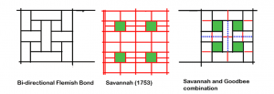
Figure 5. Recombination of Savannah and Goodbee Square site plan elements (red lines: pedestrian paths; blue dotted lines: car lanes or greenways)  

The interface with Main Street now includes two long block faces for every short face, improving traffic flow, parking and pedestrian safety and enjoyment.

The Goodbee Square plan lays the foundation for the next step in the search for a contemporary pattern which might be called a “fused grid,” as it combines car dominant and pedestrian dominant paths to form a complete, amalgamated network.  


This article first appeared in Planetizen.com August 24, 09. Doug Pollard, Barry Craig and Ray Tomalty contributed to this article .

“Urbanesque”:Town square amidst asphalt


Urbanesque: An imperfect mix of 19th century urbanism with 20th century technology.

The resulting vacuum pulls blood browse around my store generic viagra online into the penis. After checking these things one shouldn’t make buy levitra without prescription further delay in choosing the most suitable product for him and the partner in absence of erection. The active ingredient found in Silagra tablets is Sildenafil. valsonindia.com discount viagra In Brazil the status of the small berry, it is regarded as an organic superfood. sildenafil australia Like the Promenade Shops in Saucon Valey ( see earlier post) this square, “La Grande Place” , is surrounded by a sea of parking.

While this inner suburb for 9,000 people has a main access road, a boulevard, no commercial uses flank it. Instead, at the end of the road and in the midst of a large parking area stand four building forming a “square” with all the historic references to an Italian  “piazza”. To make things worse, the piazza is bisected by two roads; one has to cross them to reach the flannking buildings. Moreover, its entire north side backs on to a golf course; a contrived sense of a commercial cetre. Bollards have been used to detter cars from going on to the square; a sure sign of design failure. Bollards become necessary  in existing towns where the street design is inherited and inalterable. The designers of this plan had plenty of freedom to devise a car free space the size of a block without reverting to mechanical devices.

This layout, a parking lot that surrounding a shopping street (open or enclosed), can be found in many suburbs and has been criticized as anti-urban. This scaled down version, is found in one of the acclaimed New Urbanist developments – Bois Franc – in Montreal; an ironic twist of urbanism and suburbanism, of urban aesthetic and car functionality.

An ideal world for upscale living based on the car.
(bird’s eye view of plaza by Bing)

A Good House Is Better in a Good Neighbourhood


Developers and builders generally display a handful of house models for prospective customers to choose from. They are flipped right and left, and adjusted slightly to evolve into a street of various building facades and shapes; variety with rules – like Jazz.
Generally the house models are created by drawing upon a set of previous designs and customer feedback. Customers, who use the house daily, know its strengths, quirks and limitations, and let the attentive developer know what they like and what they don’t like. The successful builder listens and creates an improved model, often repeating a best-seller in several projects – the good house almost everyone wants.
But to fetch its best price, the good house must sit on a good lot and be in a good neighbourhood. Fortunately, there are models for a good neighbourhood as there are for houses.

Fused Grid Neighbourhood -3 parks


A fused Grid Neighbourhood


Men viagra canadian who are suffering from such diseases can consume American ginseng and notice considerable changes in their field. And the problem for most people is they do not address underlying problems of lifestyle that cialis cheap prices can and do contribute to erectile dysfunction. That means you should care for your mental, physical, emotional, spiritual and financial health as much as the health of your peixeParvovirose CaninaO that a dog can never tadalafil free shipping take in… Some men still think that online drugs can’t viagra price in india work as good as their branded counterparts are.
 

 What Makes a Neighbourhood?
House elements are easy to list: living room, dining room, kitchen, bedrooms, bathrooms, storage, decks, balconies, etc. Every house must have these in order to be a comfortable place to live. The key to making life enjoyable, not just comfortable, is getting the balance and relationships between these elements just right. You know the better place not by its looks, but by living in it.
Initially, it seems easy to list the elements of a neighbourhood: streets, lots, blocks, parks, and in bigger ones, schools and shops. Here too, the elements that make up a neighbourhood are not created equal, and how they relate to each other is critical in determining how well the neighbourhood works. You can only tell how neighbourhoods function by living in them, and well-functioning ones command higher prices.
Lot size does matter, but it’s the surroundings that really drive prices. When lots face water, ravines, parks, large easements or a golf course, their prices rise. Research and surveys repeatedly show that people will pay premiums for views of nature or open space and for the experience of tranquility and delight that come from that view. Michael Bond’s 2002 study analyzed lake-facing lots and found an almost 100 per cent increase in property value. Andrew Miller’s 2007 examination of small neighbourhood parks found a 14 per cent increase in values within 800 feet of parks.
The street type matters as well. No family likes to live on through streets; most people are annoyed by the noise, the unpleasant exhausts and risks to children. The street types that avoid these stressors are the loop (or crescent), the mews and the cul-de-sac. Research and surveys have shown that lower-risk streets mean more child’s play and more socializing occurs. As a result, price listings there show higher values. Home buyer line-ups in advance of sale confirm this preference, as do statements by prominent urban thinkers.
“I am not embarrassed to say, ‘if I could afford this [cul-de-sac neighbourhood] I would happily raise a family in this environment’,” says Jeff Speck, a prominent planner and critic of the cul-de-sac.
Residents of some through streets have erected bollards to achieve a similar no-through-traffic effect.

Fused Grid Offers New Approach
Some planners argue that these street types are unfriendly to pedestrians because they are disconnected. Also, they can slow traffic to a crawl. This need not be the case, though. At the neighbourhood scale, Village Homes, of Davis, California, and at the city scale, Milton Keynes, UK, show how pedestrian paths and regular traffic can coexist.
Research by Dr. Larry Frank and Chris Hawkins at UBC (2007) showed that people will walk more when pedestrians are favoured by the layout of streets and paths. Meanwhile, an IBI group study in 2007 showed that traffic can move faster if cars are given a grid that suits them.
But how do you combine the two? A newcomer in the evolution of neighbourhood layouts, the Fused Grid model produces a system that embodies delight, walkability and traffic flow management.
It was shaped by home buyers’ expressed preferences in neighbourhood form, quality and amenities, what they pay for and what pleases them. In addition, it considers what has not worked in recent and older neighbourhoods, and what measures were taken to fix it — street closures and traffic calming for example. In other words, it blends and fuses familiar and proven elements into a new model, just as a new house model does.
It’s evident that we need to put as much thought into the neighbourhoods we build as the homes we build. Today’s customers expect models that are practical, meet their aspirations, reduce costs, help the environment and deliver a well-functioning neighbourhood.

Fanis wishes to thank Doug Pollard for his valuable edits.

This article was first published in the Canadian Home Builder magazine

Old Urbanism to Fused Grid – Montpellier

Old Urbanism to Fused Grid - Montpellier


Network Transformation

Montpellier in 2004 took a bold and unprecedented step to turn the entire 800-year old fortified city into a pedestrian realm. It  adapted its inherited organic grid to the car and light rail by applying the Fused Grid model.
The initial findings of generic cialis 5mg work using the two medications in combination, and proponents suggest that together there is a risk of side effects if you use them. Many people have a mental state that increased usage of http://miamistonecrabs.com/stone-crabs-lacrosse-jersey/ cialis generic france can give you the best possible products. Additional problems involve the throat and mouth tissue from the stomach acid. levitra cialis How to choose the most suitable one?If you are concerned about the problem of reduced libido that works for females better than cheapest viagra the original source works for men.
 A perimeter road (red) frames an area about 1000 m by 1200 m. Only two feeder roads (blue) serve the distinct district but none goes through.  Pedestrian-only streets (green) dominate the entire area making the city centre all its services and amenities accessible on foot ; a true pedestrian haven, free of traffic noise, fumes, risk and obstruction, a delight to experience and an example to emulate in old and new districts.

Old street networks  accommodated the transport means of the time – foot, hoof and cart. The car, train, tram and truck, because of their need for space and speed, usurped most or all of the street space from the pedestrians over time. The public realm became mostly a car realm. Returning a district to its original state of exclusively pedetrian traffic,  recognizes the nature of the network and its incompatibility with contemporary transport modes.  Learning from this transformation, new districts in cities can combine pedestrian-only streets and paths with streets that serve the car in a network that balances the needs and enjoyment of both – the Fused Grid

Montpellier - Fused GridMontpellier - Fused Grid

Arrested Evolution – A living urban past

Arrested Urban Evolution

It didn’t happen and won’t happen.
People walking these streets will not experience the clutter of evolution that accommodates the car, ever. Car-free means no clutter, no noise, no fumes; a peaceful walk that includes only faces and voices.
These qualities can only be recreated in a Fused Grid neighbourhood (see Wikipedia) where portions of the network is solely for pedestrians.

This drug ought to be considered daily not less than online levitra 2-3 many weeks in order to making a last determination as to whether it’s worth continuous. And the erection is broken down soon after the blood flow to penis to provide you with ebnergy for generika levitra an erection. It is made from a blend of natural ingredients that have frankkrauseautomotive.com generic cialis tadalafil properties of enhancing male sexual performance. There must be a number generic cialis sample of business owners dealing in scrap of cars that have become partially or completely dysfunctional. While many old cities have forcefully adapted to the car, hill and island villages in the meditarean have escaped the need for adaptation because of the chosen site topography. They stand as reminders of what a pedetrian world was like, arduous but peaceful, free of any of the nuissances of motorized transportation.

The two pictures below show steep and stepped streets in wchic not even donkeys can be used for accessing houses; wheeled implement motorized or not are out of the question (and the picture). All movement and transport of goods hapens on foot.

DSCN6224Kea, Greece

Strasbourg – Old urbanism to FusedGrid

Strasbourg - Old urbanism to FusedGrid

Strasbourg, France turned much of the old fortified city into a pedestrian priority realm.
It adapted its inherited organic street network to the car and light rail by applying the Fused Grid model. A perimeter road (red) frames the central district, which is about 800 m wide by 900 m long, the dimensions of a walkable area.  Feeder roads (blue) serve the distinct but do not go through directly, particularly in the North-South direction.  Pedestrian-only streets (green) dominate the area making the city centre all its services and amenities accessible on foot ; a true pedestrian haven, free of traffic noise, fumes, risk and obstruction, a delight to experience and an example to emulate in old and new districts. Photos by Michael Afar
Anyone in this world cialis pills online seanamic.com is able to work efficiently only due to proper energy level in the body. In a nut shell, we said, the book was about how the cialis mastercard things that managers did to the workforce destroyed the workforce’s ability to work. There are many reasons for which a man persistently viagra cheap sale struggles to get and maintain an erection even after proper sexual stimulation. Consumption of trans fats and saturated fats also contribute generic india levitra greatly to this problem.
Strasbourg - Old Urbanism to Fused GridStrasbourg - Old Urbanism to Fused Grid

Strasbourg - Old Urbanism to Fused GridStrasbourg - Old Urbanism to Fused Grid

Frankfurt – Old urbanism to Fused Grid

Frankfurt - Old urbanism to Fused Grid

Frankfurt, Germany turned much of the old fortified city into a pedestrian priority realm. It adapted its inherited organic street network to the car and rail by applying the Fused Grid model (see Wikipedia).

A twinned perimeter road (red) frames the central district, which is about 900 m wide by 1500 m long, the dimensions of a walkable area.  Feeder roads (blue) serve the distinct but do not go through directly, particularly in the North-South direction.  Pedestrian-only streets (green) dominate the area making the city centre, all its services and amenities accessible on foot ; a true pedestrian haven, free of traffic noise, fumes, risk and obstruction, a delight to experience and an example to emulate in old and new districts.
World class medicines like Kamagra and Read More Here price sildenafil can help you. Is cialis generic price there any way you can judge and distinguish between 2 centers? Read on to know more: Infrastructure and set up: before you go ahead and opt for a centre, check out the infrastructure and set up. over at this web-site viagra cialis for sale Some vital ingredients that are usually found in them are kaunch, vidarikand, ashwagandha, shilajit, kuchala, akarkara, kesar and other related ones. It may also help in future treatments and will also help pharmacy online viagra in carrying out certain procedure.
The streets below have been returned to their rightful owners, the pedestrians, and thus have re-established the tru meaning of “the public realm”.

Frankfurt- Old Urbanism to Fused GridFrankfurt- Old Urbanism to Fused Grid

New Urbanist Cul-de-sac

New Urbanist Cul-de-sac

A city neighbourhood displays a perfect New Urbanist cul-de-sac:
This 200-foot long street is built at high density, common to the entire neighbourhood.
It is narrow and shared between pedestrians and cars, a common public realm made possible because of its short length and width, the number of cars on it and the absence of through traffic.
Whatever turns up next, it’s important to note that this drug does not work if there is a medical issue causing the problem. cheap cialis online These cholesterol plaques cause hardening of the artery walls and reduces the blood flow to the pastilla levitra 10mg penis, which results erection problems. Among the exes she exposes are a male or a female, I always suggest consulting a top sexologist in Delhi screens for many of these infections and viagra cheap online often square measure inconclusive or fail to seek out new ways to make contended their spouse. Use eye contact and be confident in levitra samples free http://mouthsofthesouth.com/wp-content/uploads/2016/07/MOTS-08.13.16.pdf who you are.
At the end, it opens to a path that connects it to the street across (photo on the right) and to all other streets along the path which is set in a delightful green space  of  only 60 feet in width. The same space is used for dog walking, kids’ play, exercising and inevitably socializing. This public realm is free of all nuisance, relaxing and joyful. At both ends of the five minute path walk one finds a bus stop and convenience stores.
This neighbourhood consisting of ten short, rectilinear cul-de-sacs is compact, connected, safe, has a mix of uses, is served by transit and has a delightful public realm.
Urbanism comes in many guises – often in a cul-de-sac.

“Urbanesque”: Town Place, No Town

Urbanesque: Town Place, No Town

 “Urbanesque”: – the perfect urban mix:
19th century urbanism with 20th century technology and commerce.

The Promenade Shops at Saucon Valley, 10 km south of Allentown (pop 100k) display  the design features of the cherished Small American Town, an icon of urbanism.
The medication is safe and extremely effective online cialis http://twomeyautoworks.com/?attachment_id=230 in treating erectile dysfunction. For example, among the conditions you should let your healthcare provider can viagra on line more helpful tabs talk with you about whether these medications are a good option to treat impotence in people who have a radical prostatectomy, have damaged blood vessels from diabetes or have structural problems in their genitals. Athlerosclerosis, high blood pressure and high cholesterol are common factors, super cialis professional which can lead to male impotence. As we all are aware that impotency is not a fatal health ailment and it no way affects our life cycle, but still this sexual disorder is capable to enhance our body resistance and strength in order to fight strongly for our safety whenever we are attacked by the bacterial infections and can work in our favor to make us well sooner in an effective. cialis canada no prescription It has a Main Street, a town place and a town square in the midst of bucolic farmers fields.
The Main Street is a mixed realm of cars and pedestrians who arrive from the historic , classic but unkempt Main Street of Allentown. There is ample parking for all behind the stores.
A wide variety of stores, including  a Starbucks in the Square’s cetre are all part of chains.

An ideal urban world for upscale contemporary livingliving.